News and Analysis

  • HOMA vote coming on St. Patrick’s Day

    On February 24th, City Council had a preliminary vote to move forward with a proposal for HOMA upzones across the city, and an another vote that finalizes the plan will be happening on March 17th. 

    Housing Opportunity in Mixed-use Areas (HOMA) is a Council-initiated plan to promote residential capacity. Many of the growth-related changes are coming from the state legislature, but HOMA is specific to Bellevue only.  Density will be added through rezoning, increasing heights of the zoning categories, reducing setbacks, increasing the allowable footprint of buildings, eliminating stepbacks for the upper floors, etc. 

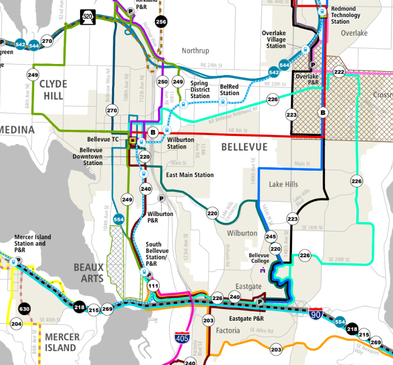
    HOMA will affect neighborhood centers (Northtowne, Newport Hills, Lake Hills) and also Eastgate, Crossroads and Factoria. It is separate from work that was recently done for Wilburton and middle housing in neighborhoods and also separate from planning that is in progress for BelRed and Evans Plaza

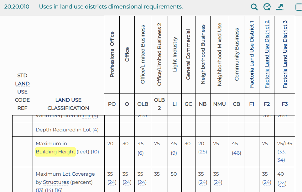
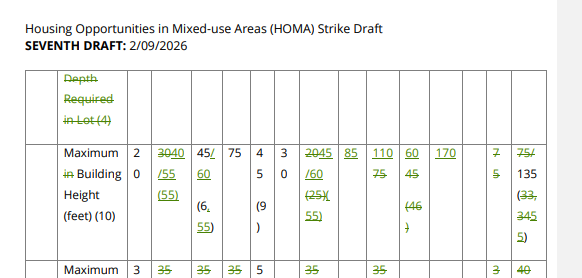
    By adding height in mixed use areas, HOMA means big changes for the properties with grocery stores that Bellevue residents depend on. If the maximum height at a neighborhood center is changed from 20 to 60 feet, it is much more likely to get a new building. There would be even taller buildings allowed in the Factoria, Crossroads, and Eastgate areas (8, 10, and 16 stories), as well as at scattered locations across the city.  

    It has been worked on by the planning staff for over a year, but substantive changes have been made quite recently.  At the end of January, Planning Commission decided the height of the MU-7 (mixed-use) category should be increased to allow 8 story buildings instead, so it will be called MU-8. On February 24th, the day of the council meeting, it turned out that the rezoning map didn’t include all the parcels that will be rezoned to allow taller buildings, so a new version was made. Some were also requesting reduced property line setbacks adjacent to single family homes so they can make their buildings larger, though this did not end up being included. At the last Council meeting about this, it was decided that stepbacks will still be required in Old Bellevue, and an opt-in provision and exemption for the floor plate increase were added.

    It is concerning that neighbors, especially near the neighborhood centers, have not been informed that they may lose the small businesses* they depend on, and that other impacts on the immediate neighbors have not been adequately explained to them (setbacks are likely to determine how much adjacent properties are affected). The community should participate in the process of deciding which amenities would justify a height increase like this. People may want space for small businesses, continued access to groceries, and childcare space, etc.  

    To put this in context, here are the heights** on parcels with grocery stores that would be allowed under HOMA, and their zoning:

    QFC in Northtowne (NB, 20 feet -> 45/60 feet)

    S-Mart in Newport Hills (NB,  20 -> 45/60 feet)

    Crossroads: 

    India Metro Hypermarket (CB (was 45 feet)->NMU, 110 feet)

    La Superior (CB, 45 -> 60 feet)

    European Grocery (CB, 45 -> 60 feet)

    Grocery Outlet (O (was 30 feet) ->NMU, 110 feet)

    (other parts of the mall are being changed to NMU and MU16, which will be 110 and 170 feet) 

    Walmart by 150th (CB (was 45) -> MU-8, 85 feet)

    Factoria: 

    T&T Supermarket (F-1, subcategory DA-I and DA-II, from 60 and 40/75 to 170 feet and 80 feet) 

    Target and former Amazon Fresh (F-1, subcategory DA-I, 60 -> 170 feet)

    QFC (CB, 45 -> 60 feet)

    Southgate Oriental Grocery (CB (was 45) -> NMU, 110 feet)

    Eastgate Plaza’s Safeway and CVS, as well as the ExtraMile and Jacksons Food Store (NMU, 75-> 110 feet)

    Lake Hills:

    IFB Market (CB (was 45) -> MU8, 85 feet)

    QFC (NB, 20 -> 45/60 feet)

    There is also a Safeway on 140th in BelRed. Since it is just east of the section of BelRed that will likely become 250′ under the BelRed Look Forward LUCA, I believe it will stay as a Mixed Use Midrise (MU-M) at 100′ – but with an additional 45′ to provide building height flexibility in the case of life sciences uses (pages 18 and 20 of that LUCA draft).

    *HOMA does include incentives for providing space for grocery stores and affordable commercial space, childcare space, and space for non-profits (page 138 of the draft), but it is not clear whether they are generous enough to result in the construction of that space. FAR exemptions can provide for a larger building only if the project is not already filling the maximum volume possible given the height cap and required setbacks.

    ** Where there are two numbers, like 45/60, the higher of the two is allowed if a small contribution is made to the affordable housing fund for each unit, $1.50 or $1.95 per sqft of a residential building (see page 66 and note (55) on page 78 of the draft).

    Note: SB 6026 (currently on the Governor’s desk) had previously required the city to allow buildings to get a 10’ height bonus in areas where we chose to require ground floor commercial space, but that height bonus was taken out by the Ways and Means committee, so I don’t think it ended up in the final version. Still, things like this could easily be added at the state level next year, which we should be mindful of in our local planning. 

    Note: There are still some things I’m not sure about – for instance, the deletion of the “DT-Tower” definition on page 111 of the draft may mean that the Tower Separation distances in 20.25A.075.B also apply to buildings that are under 100 feet, or maybe the requirement goes away entirely.

  • The Safe Speeds Survey in context

    Here’s a little background on an item from the Opportunities section of the newsletter:  

    The Safe Speeds Bellevue Survey is open until March 31st. The city wants to hear from you about the streets where speed limits were reduced and evaluated in 2025, streets where lower speed limits should be prioritized and how you would like to stay informed of the project. The survey will take approximately 5-10 minutes and your feedback will remain anonymous. All questions, including demographic questions, are optional. There are 10mph reductions proposed for W. Lake Sammamish Pkwy, part of Northrup and NE 20th, BelRed Rd, part of Kamber and SE 26th, Factoria Blvd, part of Newport Way, maybe others, and 5mph reductions in many places such as downtown, LWB, part of 114th,120th, 124th, 132nd, 148th, 140th, part of the Lake Hills Connector and many more. 

    Since the Safe Speeds Bellevue project is in the middle of the outreach and survey process, I thought I’d take a look at the results that are projected and the data that’s available from the state about our Vision Zero performance. 

    In the four arterial segments where Safe Speeds Bellevue was introduced last year to test this program (parts of Northrup Way, 124th Ave. SE, Village Park Drive, and NE 40th St.), where 35 MPH arterials were reduced to 25 MPH or 30 MPH, it is reported that the incidents of speeding over 40mph were reduced by at least 19% and up to 42%.

    Washington Traffic Safety Commission has a dashboard with the road fatality info for Bellevue. In the decade between 2015 and 2024, and deducting the crash info for 405, 90, and 520 (5 crashes), since these are not being changed, there were 19 accidents on surface streets that resulted in a death.  

    (more…)
  • Power for our new housing

    The Seattle Times has an fascinating article that talks about two big reasons new middle housing projects may need undergrounded power supplies in Seattle – electric heat pumps and EV charging capability (at a time when new projects might need power going to four or six homes per lot). 

    Adding the tubing for an underground electrical connection and making street improvements at the time of construction was said to add 6% to the cost of one recent project. Cost depends very much on whether the existing power lines are on the opposite side* of the street, and will also vary depending on whether the lengthy process of getting Seattle City Light (SCL) approvals takes months or years. 

    Under SB 5290, Bellevue and Seattle have already been working to speed up the permit review process. The developer community gets frequent updates about our average permit approval times at the Bellevue Development Committee meetings. Depending on interest rates, the approval timelines can be very important for helping a project succeed financially. It does not appear that this covers approvals from non-city entities like PSE, however, and I do not know whether they are as slow as SCL. 

    To be fair, it is hard to imagine a middle housing development like this not needing a larger water supply line, which should also require excavation, and having an underground pipe for the electrical connection also has the advantage of facilitating future communications upgrades, such as adding fiber. It’s not clear what street improvements were made as part of that 6% of cost, and if they are valuable on their own. If you have experience with this, I would be interested in hearing your take. 

    One difference in Bellevue is that EV charging/EV ready wires in the walls were not required for Middle Housing when Bellevue’s City Council voted on the new rules in June 2025. I had assumed that this would mean individual homeowners would be on the hook for installing those wires (and possibly upgrading the electrical panel) later, and that was disappointing from a sustainability and customer protection standpoint. I didn’t realize that constraints on electrical supply to the new homes might make it functionally impossible to add on later. 

    On the other hand, in Bellevue this could be a greater concern because we’re allowing more homes per lot than Seattle; builders here are able to put six units of middle housing and 2 ADUs on each lot** (though in some cases they’d need to pay in $150k each for two of those units to an affordable housing fund). Of course, it’s not a requirement that there be eight homes on each lot, and four homes per lot is more likely to give families the Bellevue suburb lifestyle with room for kids to play.

    Some of the proposals for addressing this problem: stronger poles may be able to hold up the heavier wires and larger transformers, but they are said to be unsightly (will be tested in Seattle this year, still expensive), smart panels may be able to limit EV charging when power consumption is being maxed out (a fourplex might have throttling only 1% of the time, but this is not yet approved in code), and some housing advocates say that existing residents should subsidize the new middle housing being built in their neighborhoods through a broad-based tax (though this is likely to impact residents whose homes are worth less than the new housing being added). 

    *Developers are also using AI to identify investment opportunities, probably factoring location details like this, and this is a time of particularly asymmetric information – home sellers won’t know whether their properties are potentially cheap to build on if they’re not aware of things like this and the history of recent utility upgrades in their areas. 

    **Seattle also has reductions in density if a portion of the lot is unbuildable wetland or steep slope, as is common in various jurisdictions, while Bellevue removed that provision with our recent Critical Areas Ordinance update. Bellevue is currently considering changes in the minimum lot size, which will enable twice as many units on some of the larger lots, since they could then have 8 or 24 units each, for a total of 16 or 48. 

    Note 3/6/26: House Bill 2418, sponsored by Rep. Davina Duerr (D-Bothell), standardizes and accelerates project permit review for residential housing, including parallel timing for utilities (15, 45, and 60 day clocks, up to 120 calendar days if complex). It looks like it passed unanimously in the Senate on 3/4, so we can expect this to become law.

  • Bus Map Changes

    A new bus system map and service frequency is in the works for the Eastside. An informal poll of fellow bus riders recently seems to indicate that many people don’t know their route will be canceled with the Eastlink Connections plan, even though the changes that will come with the Link’s Crosslake Connection are less than a month away. We also have a major opportunity to spread the word about increases in bus service in other places, and hopefully get new riders since some people will have bus service closer to them or connecting to new destinations.

    https://kingcounty.gov/en/dept/metro/programs-and-projects/east-link-connections

    In Bellevue, the 271 will be “replaced” by the 270 and 220, but the 270 will go north along Bellevue Way to the 520, skipping Clyde Hill (which will then get half-hourly, meandering 249 service to Spring District and South Bellevue P&R instead of a direct connection to UW), and the 220 will cross 405 on Main Street instead of NE 4th, so it will have less coverage along 116th and travel on 112th instead. Newport Way will still be served by the 203 route, and Issaquah will be served by the 218 bus, which will start at the Highlands P&R and end at the Mercer Island Link Station, rather than going all the way to Seattle.  There is a segment of W. Lake Sammamish Parkway and NW Sammamish Road where service will not be replaced. 

    Even if Newport Hill riders are not using the Link at all, hopefully they’ll have a better experience with the 240 just from the bus service increase to four buses per hour instead of three, as well as service every half hour all night. 

    There will still be a 249 bus going south of Downtown, but the northern section of its current route along Bellevue Way up to 520 will be served by the 270 instead, and it seems likely that some current 556 riders will switch to that as well.

    Changes to 550, 556, and 554 should not happen right away (some are saying October). There is information on the Annual Service Plan page, which says: “Below is an updated summary of ST Express route proposals that would be implemented beginning in fall 2026. Routes highlighted in the chart below have been updated since the last engagement period. [appears that that was November 7, 2025]” More discussion of the shift on the Seattle Transit Blog is here.

    Although it may be funny that some changes take place at the end of March and others in the fall, as asdf2 pointed out in this comment thread recently, it makes sense to have some redundancy when there might be unexpected issues with the bridge crossing. It wouldn’t be a surprise if there are outages like yesterday’s as well. The outage did stop the practice runs across the lake, though there’s no indication now of whether the schedule for opening will be affected.

    Lots of celebrations are planned for Opening Day on March 28th: BelRed’s celebration will be noon-4pm (art, drumming, pottery painting, etc). Spring District will have a petting zoo, food trucks and vendor booths from 10am-3pm. Bellevue Downtown Station will have live music, food trucks and community booths (time?). South Bellevue’s celebration (10am-2pm) will include live entertainment, food, children’s activities, community booths and a firetruck.  Mercer Island’s new station has an opening celebration from 10am-2pm, and there are shuttles starting at 7am from South Bellevue that can get you to the ribbon cutting and street fair at Judkins Park in Seattle, and there will also be celebrations at International District/Chinatown in Seattle. There will be live music at Symphony and a library-hosted stop in Lynnwood. In Redmond, there will be food provided by Microsoft and a cricket demonstration and chai truck at Marymoor. There will be a prize for the first 1000 people who collect stamps at stations along the line. (link)

    To see the changes at a glance, it might be easiest to compare the current system map with the map shown above, which you can find here. Changes to the frequency are on the individual PDFs for each route. Some info is adapted from the recent post We have a date!

    Edit: https://www.reddit.com/r/Seattle/comments/1rlqah5/full_2_line_schedules_are_up_on_google_maps/

  • Is 20% enough?

    Edit from 3/2/26: a map of parcels that are most likely to be redeveloped has been added below – Bellevue has 423 acres of parcels that are each >1 acre in size and where more of the value is in the land.

    First, I have received clarification that there were some “GIS errors” [1] with HOMA, so places like the India Metro Hypermarket actually *were* supposed to be 10 stories. The Council is set to talk about it at tonight’s meeting, so I believe they will be informed that the rezoning map that was posted on Friday is not final. 

    I also wanted to take a deeper look at ground floor commercial space in the context of SB 6026 since a well-informed reader pushed back strongly on my statement in the “Food in our future” that 20% of Bellevue’s area (where we can require a little commercial [2] to be included with a ton of residential space) will be enough to meet our needs. It is of course, far better to have 20% than the previous version of SB 6026 that would have allowed us to require ground-floor commercial space only in TOD areas, but I wouldn’t rule out the possibility that this will result in an unacceptable reduction in quality of life for Bellevue residents. 

    (more…)
  • HOMA is on the Feb 24th agenda – and an update on the grocery stores

    Edit from 3/2/26: The heights for some of the grocery store parcels listed were too low in this post, due to an error in the map provided with the meeting agenda, and it looks like I also overlooked a zoning change for the Walmart parcel – see update here or refer back to the original food post here – strikethroughs have been added to the list below.

    After my post yesterday, City Council’s agenda for next Tuesday was published, and staff is seeking direction on the HOMA proposal. If you look at the map provided with the meeting materials as Attachment 5.D, it would appear that only a few parts of the city are being affected by HOMA, but some of the areas I talked about in the last post already have NB (Neighborhood Business), CB, O, and F-1 zoning, so HOMA doesn’t need to rezone them to add capacity and increase building heights. 

    Current zoning map is here.

    Current building heights can be found here.

    As you can see in Chart 20.20.010 (scroll down to the second half that has the non-residential info), the current max heights are lower than is being planned with the HOMA changes.  The Draft included as Attachment 3.B to the agenda materials for next week’s Council meeting has 211 pages; on page 75 you can see the proposed height limits.

    Office is going up from 30 to 40/55 feet, OLB is adding the option of 15 more feet, the height listed for NB was 20′ and will be 45/60, and it references note (55). There is a new category of MU-8 that is 85 feet in height, NMU would be 110 feet instead of 75, CB will be 60 feet instead of 45, there’s a new MU-16 category that’s 170 feet, and one of the Factoria types is going from 75 to 135 feet (this last one is confusing because it has the note about alternative maximum height, but doesn’t seem to list a second number. It’s possible that it just means there’s no fee/affordability contribution required to get the 135 feet).  Building Height for the Factoria F1 zoning of the mall is not in this table, so you have to look at 20.25F1.040 (page 141 of the draft), and it will be mostly 170′ (instead of the former 60/75/45′), except for 80′ in a strip on the south side of the mall (that includes part of the T&T), which had been 40/75′.

    (more…)
  • Food in our future

    I just attended a fantastic event here in Bellevue about food robotics, with a discussion of Moto Pizza (which you can try at Bellevue Square) and how area innovators enabled them to automate and are taking the next steps to create even more flexible food handling automation. With this inspiration, here’s an overview of some food-related items around Bellevue .  

    In December, the Seattle Times reported that Amazon may run an Amazon Now site at 12368 Northrup Way that provides 30 minute gig driver delivery to zip codes 98004 in Bellevue and 98033 in Kirkland. Unfortunately, I don’t see an update on their progress, but it looks like a great location for speedy access to many parts of Bellevue. I will note that this article preceded the recent changes in direction on Amazon Fresh and Amazon Go, so I don’t know if Project Peregrine is intended to partially replace them or will also be swept up in the cancellation. 

    If you’re interested in Amazon’s food delivery, you may be interested in certain episodes of The Feed podcast that I found enjoyable: 

    https://creators.spotify.com/pod/profile/thefeedglobal/episodes/013–Vertically-integrated-food-delivery-with-Chris-Baggott-of-ClusterTruck-e11c01l

    https://creators.spotify.com/pod/profile/thefeedglobal/episodes/124–Reimagining-sustainable-online-grocery-with-Cristina-Berta-Jones-of-Picnic-e2mgfm9

    https://creators.spotify.com/pod/profile/thefeedglobal/episodes/157–Live-discussion-on-Amazons-omnichannel-grocery-strategy-e3btfnc

    In Bellevue, we’re fortunate to have options close to the former Amazon Fresh and Amazon Go, so I’m not concerned that this decision will create food deserts. There’s always some level of turnover; the T&T Supermarket opened just over a year ago, and others appear to be on the chopping block. The QFC on 8th in Downtown will be bulldozed for the Pinnacle South project (and replaced with a smaller store in Pinnacle North), and H Mart is set to become Main Street Place

    (Update has been added, see new list below) Once the HOMA upzoning Bellevue is working on now takes effect, the QFC in Northtowne and the S-Mart in Newport Hills seem likely to be redeveloped. In Crossroads, the India Metro Hypermarket, La Superior, European Grocery, and Grocery Outlet could all be redeveloped to 10 stories. The Walmart by 150th could be replaced by 8 stories, the T&T Supermarket and Target in Factoria (and the former Amazon Fresh) could be replaced by 16 stories, the QFC there could be replaced by 5-6 stories, and the Southgate Oriental Grocery by 10 stories.  Eastgate Plaza’s Safeway and QFC, as well as the ExtraMile and Jacksons Food Store could be replaced with 10 story buildings. IFB Market by the Lake Hills Library could be replaced with 8 stories, and I’m not sure what height will be allowed at the QFC in Lake Hills (it’s included on some maps too, but the StoryMap with details you can zoom in on has been taken down). Note: the maps (here and here) are from a October 8th Planning Commission meeting, so they say 7 stories, but that category was upgraded to 8 stories in the January 28th meeting. 

     Part of the HOMA discussion is how significant the incentives for including grocery should be, and how long the dedication to that use will be required to remain in place. On January 28th, the Planning Commission amended the HOMA plan to provide a 25 year limit on the grocery covenant, provided that at the end there is a transition to use with a similar level of public benefit, or fee payment. Developers were also requesting a 3:1 ratio instead of 1:1 as the incentive to put in a grocery store in the first place, but that sweetener failed on a 3:4 vote.

    (more…)
  • Speed Reduction presentation at Transportation Commission tonight

    There will be a Safe Speeds Bellevue information-only presentation, but members of the public have the opportunity to weigh in during the Oral Communications portion of the meeting (based on the agenda materials provided online). You can either sign up now or just show up at the meeting, and you also have the option to participate online or in-person at City Hall.

    The map of proposed speed limit changes will affect many streets that are currently 30 mph+, and there may also be spillover to nearby local streets. There is also an item on the agenda about funding, which will include quite a few speed bumps, but I haven’t seen a map for those.

    You may also recall that the city’s Transportation staff recently did a major outreach effort about locations where we may install speed cameras. The current program is listed here, and seven more cameras (Bellevue Way SE, Coal Creek Parkway SE, two on Forest Drive SE, 116th Avenue NE, 148th Avenue NE and NE 8th Street – see first map) will be installed in 2026, with a number of other locations identified for future years. The speed camera program was discussed at City Council on December 2nd, 2025.

    It is disappointing that the camera outreach and survey was not conducted when the public would be able to see it in context with these big changes for the speed limits, but I’m generally a supporter of camera enforcement. It will be interesting to see in the presentation tonight what legwork has been done for the Safe Speeds program to make sure that such sweeping changes won’t cause problems, and also see what the expected timeline is.

    Since this is only an informational presentation, I don’t think the Transportation Commission will be asked their opinion on the speed limit changes. I hope the community can still be heard about the importance of adding traffic-calming to local streets in parallel with any arterial changes, in order to avoid new cut-through traffic.

    See camera maps below:

    (more…)
  • I was wrong – and an IOC for Old Bellevue

    During the middle housing debate, something that appeared to be true to me was that the housing urbanists** didn’t understand the implications of the proposal, since they were advocating so strongly for rules that would allow 10,000+ sqft duplexes, among other things – it seemed off-brand.  

    An article that came out in November suggests that I was wrong about this, since the question in Clyde Hill’s case was specifically about the possibility of 5000 sqft “cottages” and their article still expressed a preference for that in the strongest terms, rather than a rule allowing a more typical cottage size that would be much more affordable. (It also seems possible there’s just a general antipathy toward Clyde Hill and the people who live there. Remember, there was a different Urbanist article last summer where they and Bainbridge Island were callously referred to as a “crash-test dummies“.)

    There’s a similar situation that arose in Bellevue, with multiple 9-unit buildings that were built as part of a single project (to avoid triggering the 10 unit requirements for affordable housing). This was discussed in a December 10th Planning Commission meeting (Slide 11 of the presentation, timestamp 17:00-17:30) and the fix to address this will just be put in during the next code update that’s somewhat related.

    Bellevue also has an emergency option called an Interim Official Control, which is authorized by state law under RCW 36.70A.390 (Clyde Hill mentions both that and RCW 35A.63.220 as supporting their interim zoning control).

    In a recent example, we’ve used an IOC to add density (Ordinances 6736/6760/6785), but the IOC in Ordinance 6903 that will be considered by the City Council next week will put a hold on changes to the character of the Old Bellevue section of Main St between 100th and Bellevue Way. This IOC focuses on facade retention rather than reducing the overall scale of any new buildings, and this is also in the context of HOMA densification* that also appears likely in the near term.

    This looks like a good use of the IOC option, and it will be interesting to hear the Council’s discussion on Tuesday!

    *If you would like to see things I’ve written about HOMA, there are some summaries in the newsletter archives, which can be found using the link on the upper right. I did also comment on HOMA at the January 25th Planning Commission meeting to draw commissioners’ attention to SB 6026, which might upend Bellevue’s plans to balance commercial and residential growth as we enable housing in areas that have held retail centers and offices.

    ** In contrast, I consider myself a “generalist urbanist” because I care about creating wide sidewalks, retaining tree canopy, EV ready middle housing, better apartment noise-proofing, adequate off-street parking in neighborhoods, and promoting commercial space for small businesses to thrive. All of these things in Bellevue have recently been attacked by the housing urbanists because they *do* make it more expensive to build housing, but I believe they still have value for making Bellevue a place that people will feel fortunate to live in.

    One more note: if you have commented on this site, please try also to reach out to me by email so I can let it through the spam filter, which has been somewhat deluged.

    Added Note: I haven’t watched the meeting recording on YouTube yet, but it was surprising during the public comment that there were multiple property owners who appeared to be blind-sided by this proposal, and said that they’d only found out the morning of Feb 10th. There was an article you can find here that came out about it 2 months ago.

    https://www.reddit.com/r/BellevueWA/comments/1pev8zo/mayor_scrambles_to_protect_character_of_old/

    Added Note 2 (2/12/26): An update from the February 10th meeting has been added on The Urbanist.

  • We have a date!

    The Link’s Crosslake Connection was just announced yesterday as starting on March 28th. Is it a surprise? Not really. Back in September, the bus schedules partially shifted in recognition of the upcoming Crosslake service, and the dates on the bus schedules issued back then say that they’re effective through March 27th.

    So here’s the PSA: A new bus system map and service frequency is in the works for the Eastside, and I hope you’ll take a look to see whether any of these changes might affect you. They may make it easier or harder for you to reach a Link station or change the desirability of using the bus on its own.

    https://kingcounty.gov/en/dept/metro/programs-and-projects/east-link-connections

    One example is the 271.  In Bellevue, this will be “replaced” by the 270 and 220, but the 270 will go north along Bellevue Way to the 520, skipping Clyde Hill (which will then get half-hourly, meandering 249 service to Spring District instead of a direct connection to UW), and the 220 will cross 405 on Main Street instead of NE 4th, so it will have less coverage along 116th and travel on 112th instead. Newport Way will still be served by the 203 route, and Issaquah will be served by the 218 bus, which will start at the Highlands P&R and end at the Mercer Island Link Station, rather than going all the way to Seattle.  There is a segment of W. Lake Sammamish Parkway and NW Sammamish Road where service will not be replaced. 

    Many riders will also care about the bus frequency and hours. While I don’t think the 240 bus is having additional modifications to its route, there will be an increase in service to four buses per hour instead of three, as well as service every half hour all night.  Many riders may not be using the Link at all, but hopefully they’ll have a better experience in Newport Hills just from the bus service increase.

    I know it’s not easy to look at this and tell where the modifications are. For instance, on the B Line, there is a note saying that the route should now be more direct, but the shape of the route looks approximately the same as it is now (individual bus stops are not identified), so it’s possible that any changes to the route were part of the first round of changes* that took effect at the beginning of September. It appears from a quick scan that B line service on weekend evenings will be reduced by 1-2 buses per hour, and there may be other changes I didn’t notice.  

    Keep an eye out for other swaps as well. There will still be a 249 bus going south of Downtown, but the northern section of its current route along Bellevue Way up to 520 will be served by the 270 instead, and it seems likely that some current 556 riders will switch to that as well.

    When you look at the buses listed on the East Link Connections, you may need to open multiple individual route pdfs to figure out where the transfer points might be. Also, the current route maps are labeled but not to scale and the new maps are to scale but not labeled. I’m looking forward to using Google Maps, but right now when I search for a transit ride in April, it still shows me the existing bus routes. I don’t think they will update it until a new bus map is officially published. To see the changes at a glance, it might be easiest to compare the current system map with the map shown below, which you can find here.

    Really, we don’t know for sure what will be happening until the new bus routes are released. The East Link Connections webpage has been a great resource for long-term conceptualization of what to expect, but if people have concerns with the proposed changes, it’s still possible they’d be willing to modify the plan. I hope you’ll take a look at the planned service for your area and let them know right away if you have concerns! You can use haveasay@kingcounty.gov to reach out to the East Link Connections team.

    * Edit: I went back and looked at the revisions map, and actually, the B Line did not change in September. It’s possible there are some small changes still to come that I just had a hard time seeing. I’ve also added more info and links above.

    If you liked this post, you may also be interested in this description and opportunity for feedback that was posted by STB.

    It looks like the changes to 550, 556, and 554 may not happen right away. There is information on the Annual Service Plan page, which says: “Below is an updated summary of ST Express route proposals that would be implemented beginning in fall 2026. Routes highlighted in the chart below have been updated since the last engagement period. [appears that that was November 7, 2025]”

    https://www.soundtransit.org/system-expansion/planning-future-service/2026-service-plan